Hell’s Gate Wildfire Erupts Near Boston Bar, Surges to 40 Hectares and Triggers Evacuation Alerts
The spring wildfire season has arrived with alarming force in British Columbia. On April 24, a blaze that started small near the historic Hell’s Gate in the Fraser Canyon exploded virtually overnight, scorching 40 hectares of steep, forested terrain and forcing the regional district to issue evacuation alerts for properties west of the communities of Boston Bar and North Bend. What began as a 0.3-hectare spot fire—barely a few hundred square metres—transformed into a fast-moving interface fire, drawing a massive suppression response and reminding residents just how quickly the landscape can turn volatile.
In this deep-dive update, we’ll break down everything you need to know about the Hell’s Gate wildfire, from its overnight growth and the resources deployed to contain it, to the evacuation measures, local weather patterns, travel impacts, and practical steps you can take to stay safe as the situation evolves.
Rapid Overnight Growth and the Flurry of Response
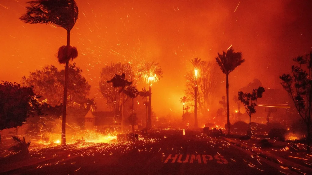
The BC Wildfire Service first logged the Hell’s Gate fire on the afternoon of Thursday, April 24. At the time, it measured a mere 0.3 hectares and was burning in a remote, hard-to-access area north of the Hell’s Gate Airtram, a famous tourist attraction perched above the churning waters of the Fraser River. Within hours, the fire’s footprint swelled to 40 hectares—an area roughly equivalent to 75 football fields—catching fire behaviour specialists and local crews off guard.
Witnesses described a towering column of smoke visible from the Trans-Canada Highway, while glow from the flames reflected off the canyon walls after sunset. The BC Wildfire Service responded aggressively, deploying:
- Air tankers and birddog aircraft to lay retardant lines and slow the head of the fire
- Helicopters bucketing water from the Fraser River onto hot spots
- Ground crews including initial attack teams and a unit crew working to build containment lines
- An incident management team to coordinate logistics and triage resources
Fire officials noted that the fire exhibited Rank 3 and Rank 4 behaviour—meaning an organized surface flame front with occasional torching of individual trees—which is unusually intense for April in that part of the province. The rapid spread was fuelled by a combination of fine, dry fuels (cured grasses and needle cast), strong outflow winds from the north, and daytime temperatures that pushed into the mid-20s Celsius—well above seasonal norms.
Evacuation Alerts and the Affected Properties
By late Thursday evening, the Fraser Valley Regional District (FVRD) issued an evacuation alert covering roughly 30 properties along the west side of the Fraser River, stretching from the mouth of Anderson Creek south to the Hell’s Gate Airtram site. An evacuation alert does not mean residents must leave immediately, but it’s a critical warning to be ready to go on a moment’s notice.
The designated area includes a mix of permanent residences, recreational cabins, and several Indigenous archaeological and cultural sites of profound significance to local First Nations, particularly the Nlaka’pamux people. The FVRD and BC Wildfire Service have been working closely with First Nations representatives to safeguard cultural values while suppressing the fire.
Under the evacuation alert, affected households should:
- Gather essential documents, medications, and a 72-hour emergency kit
- Plan an evacuation route and identify a safe meeting place
- Arrange accommodation with family or friends outside the alert zone
- Pre-register for Emergency Support Services (ESS) online via the provincial ERA tool
- Keep phones charged and monitor DriveBC and the FVRD website for updates
No structures have been reported lost as of the latest mapping update, and the fire remains classified as Out of Control, meaning it is not expected to be contained by the current suppression efforts alone. Firefighters are concentrating on anchoring the southern flank near the Airtram to protect critical infrastructure, using natural barriers like rocky outcrops and the river itself as firebreaks.
Highway 1 and Travel Advisories in the Canyon
The Trans-Canada Highway (Highway 1) runs along the eastern bank of the Fraser River directly opposite the fire. While the highway has not been closed, visibility reductions due to thick smoke prompted the Ministry of Transportation to issue a travel advisory for the stretch between Yale and Lytton. Drivers reported patches of near-zero visibility, especially during the early morning hours when cooler air trapped smoke at river level.
Travel tips for anyone driving the Canyon corridor right now:
- Slow down and use low-beam headlights—not high beams—in smoke
- Watch for wildlife that may be fleeing the fire zone
- Do not stop on the highway to take photos or watch the fire; this interferes with emergency vehicle access
- Check DriveBC.ca for real-time road conditions before departing
The Hell’s Gate Airtram suspended operations on Friday, April 25, both out of an abundance of caution and because access roads near the base terminal were being used by fire crews moving equipment. The suspension will remain in effect until the BC Wildfire Service deems the area safe.
What’s Driving the Fire: Weather and Fuel Conditions
The Hell’s Gate wildfire is not an isolated event; it is symptomatic of a broader pattern of early-season dryness gripping much of the BC Interior. Following a below-average snowpack winter and an exceptionally warm March, the Fraser Canyon’s forest fuels are primed to burn weeks ahead of what used to be considered “fire season.”
Key contributing factors:
- Dry lightning-free spring: For weeks, the region has seen sunshine and low humidity without the cleansing effect of widespread rain
- Above-average temperatures: Boston Bar consistently hit 23–26°C in the days leading up to the fire, eroding residual soil moisture
- Dead and downed woody debris: The area is covered with standing dead timber from past pine beetle outbreaks and blowdown events, adding significant fuel load
- Katabatic winds: Nighttime down-canyon winds regularly funnel through the Hell’s Gate narrows, pushing flames and embers unpredictably
Biologists and fire ecologists also note that the Hell’s Gate area has a long history of periodic wildfire. The steep, dry ponderosa pine and Douglas-fir forests rely on low-severity fire to regenerate. However, decades of aggressive suppression have built up dense understories, turning what would naturally be a surface fire into a more dangerous crown fire threat. This historical context means the BC Wildfire Service must balance aggressive suppression with long-term ecosystem resilience—a challenge that will only intensify as climate change extends the fire season.
Smoke Impacts and Air Quality Alerts
Wildfire smoke from the Hell’s Gate fire has been drifting north and east, affecting air quality in the communities of Lytton, Spences Bridge, and Cache Creek. On Friday morning, the BC Air Quality Health Index registered as “moderate to high risk” for these areas, with fine particulate matter (PM2.5) concentrations spiking during the overnight inversion.
Health authorities advise residents, especially those with asthma, COPD, heart disease, or who are pregnant, to:
- Stay indoors and keep windows closed
- Use a high-efficiency particulate air (HEPA) purifier if available
- Limit strenuous outdoor activity
- Wear an N95 respirator if you must go outside for extended periods
- Check the BC Air Quality website for hourly updates
The Fraser Canyon Hospital in Hope has not reported a surge in respiratory-related visits, but officials remain on alert as the fire is expected to continue burning actively through the weekend. Smoke forecasting models suggest that a shift to southwesterly winds could push plumes back toward the Lower Mainland by Sunday, potentially bringing hazy skies to the Fraser Valley and Metro Vancouver.
Community and First Nations Coordination
The Hell’s Gate area cuts through the traditional territories of several Nlaka’pamux communities, including Boston Bar First Nation and Boothroyd Indian Band. From the moment the fire was spotted, First Nations emergency coordinators activated their own mutual-aid agreements and began working alongside BC Wildfire Service personnel, the FVRD, and EMBC (Emergency Management BC).
Nation-led Guardian programs helped identify culturally sensitive sites—such as ancient pithouse depressions, pictographs, and traditional plant-gathering locations—so that bulldozer lines and fire breaks could be rerouted to avoid causing irreversible damage. This collaborative emergency management model is increasingly becoming the standard in BC, and it has proven essential in past incidents like the 2021 Lytton Creek fire and the 2023 Bush Creek East blaze.
Residents in the evacuation alert zone are also receiving alerts through the FVRD’s Voyent Alert! app, which delivers push-notifications, texts, and emails customized to geographic areas. Anyone living in or travelling through the region is encouraged to download the app and register with their current location.
How to Prepare an Emergency Go-Bag
With evacuation alerts in place, now is the ideal time to build or refresh your wildfire go-bag. A well-stocked bag can make the difference between a frantic scramble and a calm, orderly departure. Below is a wildfire-ready packing checklist:
- Essentials pouch: Passports, birth certificates, insurance documents, digital backups on a USB drive
- Medications & prescriptions: A week’s supply plus a list of dosages and doctor contacts
- Water and non-perishable food: Enough for at least 72 hours (granola bars, canned goods, dried fruit)
- First-aid kit: Bandages, antiseptic wipes, pain relievers, any personal medical devices
- N95 masks: For smoke protection, critical if you have respiratory conditions
- Flashlight & headlamp: With extra batteries; power banks for phones
- Warm clothing & sturdy shoes: Even in spring, canyon nights are cool
- Pet supplies: Leash, carrier, food, vaccination records
- Sentimental items: Family photos, small heirlooms—things that can’t be replaced
Store your go-bag near an exit door and keep your vehicle fuel tank at least half full. Pre-plan at least two different escape routes in case one is blocked by smoke, debris, or emergency vehicles.
What’s Next: Containment Outlook and Long-Range Forecast
As of Saturday morning, the Hell’s Gate wildfire remains at 40 hectares and is listed as “out of control,” but fire managers are cautiously optimistic that an aggressive initial attack has halted its forward progression. Crews are working to build a containment line along the southern perimeter, while helicopters continue bucketing on the northern flank where steep terrain makes ground access hazardous.
Weather over the weekend will be a critical factor. Environment Canada forecasts daytime highs of 22–24°C with relative humidity dropping below 20% in the afternoon, but winds are expected to be lighter than on Thursday. A chance of isolated thundershowers on Sunday afternoon could bring welcome moisture—or, problematically, dry lightning that sparks additional starts. Fire behaviour analysts are closely monitoring potential lightning cells and will pre-position additional airt