Tropical Cyclone Vaianu Threatens New Zealand With Severe Winds
A powerful and dangerous weather system is churning across the South Pacific, setting its sights on New Zealand. Tropical Cyclone Vaianu, having already impacted Fiji, is forecast to bring a period of severe and damaging weather to the country, with meteorologists warning of potentially destructive winds, heavy rainfall, and coastal hazards.
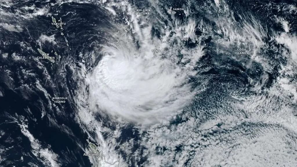
From the Tropics to the Tasman: Vaianu’s Forecast Path
Tropical Cyclone Vaianu intensified rapidly over warm ocean waters northeast of Fiji. After passing through the Fijian archipelago, bringing torrential rain and gusty winds, the system has begun its transition into an extra-tropical cyclone. This metamorphosis does not mean the storm is weakening in a way that lessens the threat; instead, it signifies the cyclone is merging with mid-latitude weather systems, which can expand its wind field and increase its forward speed.
The latest tracking models indicate Vaianu is on a firm south-southeast trajectory, aiming directly for the North Island of New Zealand. Forecasters predict the system’s center will approach the northeastern coast from Sunday evening through Monday. The entire upper North Island, particularly Northland, Auckland, Coromandel Peninsula, and the Bay of Plenty, is in the firing line for the most severe conditions.
Key Impacts and Hazards for New Zealand
The combination of Vaianu’s remnants and an existing trough of low pressure is expected to create a significant and widespread weather event. Residents are urged to prepare for the following primary hazards:
1. Severe and Destructive Wind Gusts
This is the most significant threat. As the system approaches, northeasterly winds are forecast to increase sharply.
* Peak Wind Gusts: Coastal areas of the upper North Island could experience severe gale-force winds with gusts exceeding 130 km/h. In the most exposed places, such as headlands and higher terrain, gusts may reach 140 km/h or more, which is capable of causing structural damage.
* Potential Damage: These winds can tear roofs from buildings, topple trees and power lines, and turn unsecured objects into dangerous projectiles. Widespread power outages are likely.
2. Heavy, Intense Rainfall and Flooding
Vaianu will tap into a moist tropical airmass, unleashing a deluge of rain.
* Rainfall Totals: Forecast models predict 100 to 150 mm of rain could fall in 12-18 hours, with localized amounts of 200 mm or more possible, especially in north-facing hills and ranges.
* Flooding and Slips: This intensity of rainfall will lead to dangerous flash flooding, rapid river level rises, and a high risk of landslides and slips. Low-lying areas and communities near rivers and streams are particularly vulnerable.
3. Coastal Inundation and Large Swells
The powerful onshore winds will create dangerous marine conditions and coastal hazards.
* Storm Surge: A storm surge, combined with large waves, may lead to coastal inundation (seawater flooding) around high tide times, especially in northern and eastern harbors.
* Enormous Waves: Wave heights in exposed waters could reach 8-10 meters. These waves will cause significant erosion and pose an extreme danger to anyone near the shoreline.
Official Warnings and How to Prepare
MetService and the National Emergency Management Agency (NEMA) have issued severe weather watches and warnings, which are expected to be upgraded as the event draws nearer. It is critical that residents in the affected regions take steps to prepare immediately.
Before the Storm Arrives:
* Secure Your Property: Tie down or bring indoors any loose items like trampolines, outdoor furniture, and rubbish bins. Check your roof and gutters for loose fittings.
* Prepare for Outages: Assemble an emergency kit with torches, batteries, a battery-powered radio, water, and non-perishable food. Ensure mobile devices are fully charged.
* Create a Plan: Discuss with your household what you will do if you need to evacuate or if you are separated. Know where your local civil defense center is.
* Stay Informed: Monitor official forecasts from MetService and alerts from NEMA or your local Civil Defence Emergency Management Group. Do not rely solely on social media.
During the Storm:
* Stay Indoors: Do not travel unless absolutely necessary. The safest place is inside a sturdy building.
* Avoid Floodwaters: Never walk, swim, or drive through floodwater. It may be deeper or faster-flowing than it appears and could be contaminated.
* Listen to Authorities: Be ready to follow any official evacuation orders or instructions.
The Bigger Picture: Climate Change and Intensifying Storms
While cyclones are a natural part of the South Pacific’s climate system, scientists warn that a warming planet is influencing their behavior. Climate change is linked to higher sea surface temperatures, which provide more energy for cyclones to form and intensify. Furthermore, a warmer atmosphere can hold more moisture, leading to increased rainfall rates during these storms.
The potential severity of Tropical Cyclone Vaianu serves as a stark reminder of New Zealand’s vulnerability to extreme weather events. It underscores the importance of robust infrastructure, effective early warning systems, and community preparedness in building resilience for a future where such intense storms may become more frequent.
As the nation watches and prepares, the message from officials is clear: take this threat seriously. Prepare your home, make your plan, and stay updated with official information. The coming 48 hours will be a critical test as New Zealand braces for the fierce winds and lashing rain of Tropical Cyclone Vaianu.