
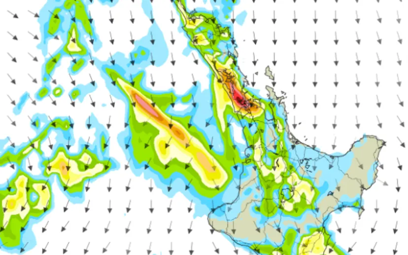
Heavy Rain and Thunderstorms Could Affect Auckland and Northern New Zealand
Imagine stepping outside in Auckland expecting an ordinary rainy day, only to encounter intense downpours, thunderstorms and rapidly rising water on nearby roads. That is the type of weather residents in parts of New Zealand’s North Island have been warned to prepare for as severe thunderstorms threaten to bring exceptionally heavy rainfall.
New Zealand’s MetService has issued a Severe Thunderstorm Watch covering the northern half of the North Island, with localised rainfall potentially reaching between 25 and 40 millimetres per hour, or possibly more in some areas. The conditions could create dangerous situations, particularly in locations vulnerable to surface flooding, flash floods and landslides.
Auckland and Northland are among the areas facing a heightened risk, while the wider warning also includes several other regions across the North Island.
MetService Warns of Intense Localised Rainfall
The main concern is not simply the amount of rain expected throughout the day. Instead, meteorologists are highlighting the possibility of concentrated rainfall occurring over a relatively short period.
According to the MetService warning, severe thunderstorms could produce rainfall rates of 25 to 40 millimetres per hour. In some locations, the downpours could exceed that range.
Such intense rainfall can overwhelm drainage systems, particularly in urban neighbourhoods where rainwater has limited space to flow away. Roads, footpaths and low-lying properties may become flooded when large amounts of water accumulate quickly.
The weather agency has also highlighted the possibility of flooding around streams, rivers and narrow valleys. These locations can become particularly hazardous when heavy rainfall causes water levels to rise rapidly.
Although thunderstorms may not affect every location equally, residents within the watch area are being encouraged to remain alert because localised storms can produce significantly different conditions over relatively short distances.
Which Areas of the North Island Are Under the Weather Watch?
The Severe Thunderstorm Watch covers a substantial section of the North Island. Areas included in the warning are:
- Northland: Including areas around the region’s northern communities.
- Auckland: Including the wider Auckland metropolitan area.
- Great Barrier Island: Also included in the northern weather watch.
- Coromandel Peninsula: Where thunderstorms and heavy rainfall are possible.
- Waikato: Including areas exposed to the wider unsettled weather system.
- Waitomo: Another area included in the warning.
- Taumarunui: Also covered by the regional weather alert.
- Bay of Plenty: Residents should monitor changing weather conditions.
- Rotorua: Included in the wider warning area.
- Taupo: Also covered by the thunderstorm watch.
- Taranaki: Included in the broader regional alert.
- Taihape and Wanganui: Also identified in the warning area.
However, being inside the watch area does not mean every community will experience severe thunderstorms. The risk varies by location, and individual thunderstorms can develop and move unpredictably.
Residents should therefore follow location-specific forecasts rather than assuming that conditions will remain the same throughout the region.
When Could the Severe Thunderstorms Develop?
The timing of the weather system is particularly important for people planning their activities, commuting or travelling between communities.
The MetService warning indicated a moderate risk of severe thunderstorms developing across the northern half of the North Island from around midnight Friday until midday Saturday, November 7, 2026.
The risk was expected to ease in northern parts of the affected area from around dawn onwards. However, this does not mean that all unsettled weather would immediately disappear once the most significant thunderstorm risk had passed.
Rain and showers could continue in some locations, and conditions may differ depending on the movement of the weather system.
People should check updated MetService forecasts and warnings before making travel arrangements, particularly if their plans involve areas that have experienced heavy rainfall.
Flash Flooding and Landslides Are Among the Main Concerns
One of the biggest dangers associated with severe thunderstorms is the speed at which flooding can develop.
When rainfall reaches 25 to 40 millimetres per hour, water can accumulate faster than local drainage systems can handle. This can result in surface flooding, especially in urban environments and places with poor drainage.
Streams, rivers and narrow valleys are also vulnerable. Water levels can increase quickly during intense rainfall, potentially making nearby roads, walking paths and surrounding areas dangerous.
Another concern is the possibility of landslides and slips. Heavy rain can saturate the ground, reducing its stability and increasing the possibility of soil and debris moving down slopes.
Properties located near steep slopes or areas with a history of ground movement should be monitored carefully during prolonged or particularly intense rainfall.
These hazards are not necessarily limited to locations experiencing the strongest thunderstorm activity. Heavy rainfall upstream can also affect waterways farther away from where the rain originally falls.
Driving Conditions Could Become Dangerous
Motorists across Auckland and other affected North Island regions should take extra precautions when travelling during thunderstorms.
Heavy rainfall can reduce visibility, making it harder to identify road markings, pedestrians, cyclists and other vehicles. Water accumulating on roads can also increase the risk of losing control, particularly when drivers travel too quickly for the conditions.
Flooded roads present an additional danger because the depth and movement of water may be difficult to judge from inside a vehicle.
Drivers should never attempt to cross floodwater when the depth or condition of the road is uncertain. Even seemingly shallow water can create dangerous driving conditions.
Anyone who must travel should consider checking weather forecasts, traffic updates and road conditions before leaving. Allowing additional travel time and avoiding unnecessary journeys during intense downpours can also reduce exposure to dangerous conditions.
How Auckland Residents Can Prepare for Severe Weather
Preparing before thunderstorms arrive can help households reduce the potential impact of heavy rainfall and flooding.
Residents in Auckland and surrounding communities can take several practical steps while monitoring the weather warnings.
1. Check Local Weather Updates
Follow the latest forecasts and official warnings from MetService. A Severe Thunderstorm Watch indicates that conditions are favourable for severe thunderstorms, but it does not mean that every location will experience them.
Pay attention to any changes in the warning level, particularly if a watch is upgraded to a Severe Thunderstorm Warning for a specific location.
2. Keep Stormwater Drains Clear
Check accessible outdoor drains and gutters around your property. Removing accumulated leaves and other debris can help rainwater flow away more effectively.
However, avoid entering flooded areas or attempting to clear drains during dangerous weather conditions.
3. Secure Outdoor Items
Bring lightweight furniture, garden equipment and other loose objects indoors or secure them properly. Strong winds associated with thunderstorms can move unsecured items and potentially cause damage.
4. Prepare Essential Supplies
Keep a flashlight, charged mobile phone, drinking water and essential household supplies accessible. Power interruptions can occur during severe weather, so having basic emergency equipment ready is sensible.
5. Stay Away From Floodwater
Avoid walking, swimming or driving through floodwater. Stay clear of swollen rivers, streams and other waterways because water levels and currents can change rapidly.
Auckland Emergency Management Highlights Flooding Risks
Auckland Emergency Management has also highlighted the potential consequences of intense rainfall, including flash flooding and slips.
These warnings are particularly relevant to Auckland residents because heavy rainfall can affect both residential neighbourhoods and major transport routes.
Low-lying properties, roads near waterways and areas with a history of flooding may require additional attention during severe weather.
Residents should also know where to find local emergency information and how to respond if their property becomes threatened by rising water.
If flooding begins to affect a home or surrounding area, personal safety should take priority over protecting possessions. People should move away from dangerous locations and follow instructions from emergency services.
What Residents Should Watch for Next
The severe thunderstorm watch is a reminder that weather conditions can change quickly across New Zealand’s North Island. Even when the forecast identifies a particular period of increased risk, the exact location and intensity of individual thunderstorms can remain difficult to predict.
For Auckland residents, Northland communities and people travelling through the upper North Island, checking official weather updates should remain a priority throughout the warning period.
MetService provides updated forecasts and severe weather information through its official website at metservice.com. Auckland residents can also consult Auckland Emergency Management for local preparedness information.
With rainfall potentially reaching 40 millimetres per hour or more in localised areas, avoiding floodwater, preparing for sudden downpours and staying informed are practical steps residents can take. Conditions should continue to be monitored as the weather system moves across the North Island and the thunderstorm risk changes.